Adding a New Custom Base Map
Hortis lets you add custom base maps by connecting to any compatible map service. To add one:
- Go to Site Settings → Maps
- Click + Create New
- Enter a Display Name and the Service URL (Tiles URL)
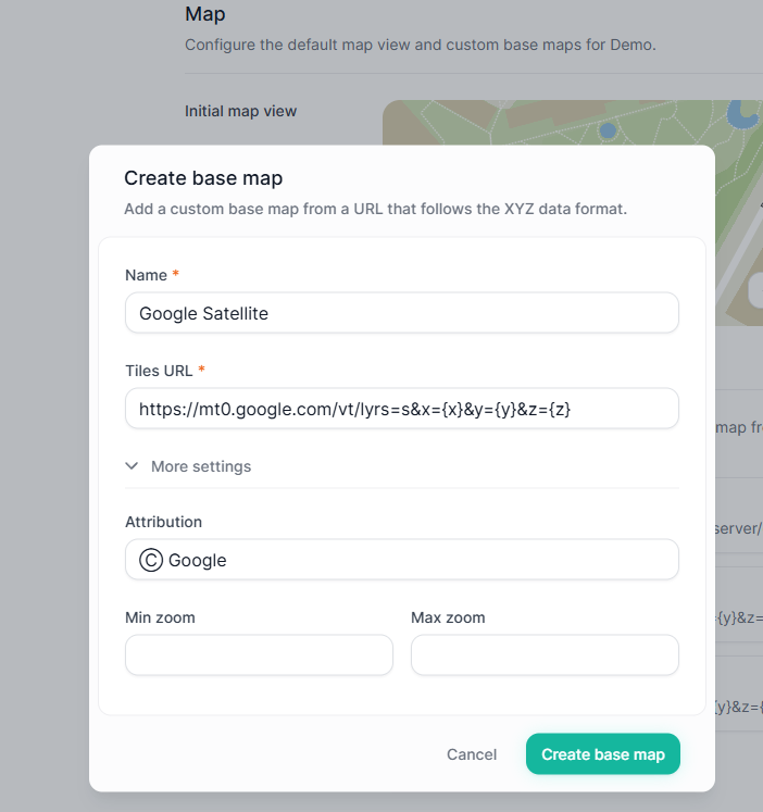
In the example below, we are adding a Google Satellite base map. Instructions for connecting to a variety of other common map service providers are found below.
Base Map Service Requirements
Requirements:
The URL must include the
x,y, andzparameters (see examples below).The map must use the Web Mercator projection (EPSG:3857) [link].
Ensure you understand and comply with any attribution requirements of the map service.
Using Your Own Map Server:
If you are connecting to a self-hosted map server, we may need to whitelist the service address in Hortis to enable data loading. Please contact support for assistance.
Learn More:
More information about XYZ Tiled Web Maps (Also known as slippy map) is available here [link].
Below, you will find instructions for connecting to popular online map services. If your preferred service is not listed, let us know.
Map Service Examples
- Esri ArcGIS Online
- Web Map Tile Service (WMTS)
- Nearmap
- OpenAerialMap
- Ordnance Survey (UK)
- Stadia Maps
Esri ArcGIS Online
ArcGIS Online is a complete mapping and analysis solution. You can use it on its own or expand your work using other ArcGIS products.
ArcGIS is a paid service.
Connecting to your own ArcGIS maps
To connect to your own maps, you can either publish your map as a Web Map Tile Service (WMTS) or prepare a tile map package file and to upload to your ArcGIS Online Account. Before you start, make sure your map is set up with the Web Mercator projection (EPSG:3857). Please note that ArcGIS online may have restrictions on sharing large aerial maps to everyone (public).
Publish as a WMTS Service with ArcGIS Pro
- In ArcGIS Pro, open your map and go to Share > Web Layer > Publish Web Layer.
- Set the layer type to Tile.
- Set Sharing Level to Everyone (public).
- Under the Configuration tab.
- ensure the tiling scheme is set to ArcGIS Online / Bing Maps / Google Maps.
- Levels of Details is recommended to be set to 15-21 or potentially 16-22, depending on the size and levels of details of your map.
- Click Publish. Once complete, the tile layer will appear in your ArcGIS Online Content.
- In ArcGIS Online, open the page for your newly published tile layer.
- Click the source Map Service link or use the service URL to access the service directory page.
- On the Service Directory Page, click the WMTS link on top to access the service definition.
- In the XML service definition, locate the ResourceURL.
- The resource URL would look something like this:
- https://tiles.arcgis.com/tiles/ZCPxyWsXwAcvsaA8K/arcgis/rest/services/My_Hortis_Map/MapServer/WMTS/tile/1.0.0/My_Hortis_Map/{Style}/{TileMatrixSet}/{TileMatrix}/{TileRow}/{TileCol}.png
- Replace the {Style}, {TileMatrixSet}, {TileMatrix}, {TileRow}, and {TileCol} placeholders. On ArcGIS Online, the default style is default and the default tile matrix set is default028mm. Replace accordingly so the URL ends with default/default028mm/{z}/{y}/{x}.
Your Hortis service URL should look something like this: - https://tiles.arcgis.com/tiles/ZCPxyWsXwAcvsaA8K/arcgis/rest/services/My_Hortis_Map/MapServer/WMTS/tile/1.0.0/My_Hortis_Map/default/default028mm/{z}/{y}/{x}.png
Publish a Map Tile Package File
Please follow these steps:
Create a Map Tile Package with ArcGIS pro [link].
Log in to your ArcGIS online account, navigate to Content and click Add. Select your new tile package file (.tpkx or .tpk file).
With the new “Tile layer”, change “Share” to Everyone (public). [link]
Copy the “URL” found at the bottom right of the screen to clipboard.
Paste the URL into settings in Hortis and append “/tile/{z}/{y}/{x}” at the end.
URL Format:
<Tile Layer URL>/tile/{z}/{y}/{x}URL Format example (fictitious):
https://tiles.arcgis.com/tiles/ZCPxyWsdgewc58dfK/arcgis/rest/services/OurGarden/MapServer/tile/{z}/{y}/{x}Connecting to Esri base maps
Esri ArcGIS online also offers a number of base maps of which a list can be found here [link].
Example URL for Esri World Imagery
https://server.arcgisonline.com/arcgis/rest/services/World_Imagery/MapServer/tile/{z}/{y}/{x}Web Map Tile Service (WMTS)
If you have a map available through WMTS, you can configure Hortis to connect to the Tilematrix endpoint.
The WMTS specification page is normally available via the service home page. By accessing the WMTS specification page, navigate to the ResourceURL entry where you will find the template entry that should look something like this (This example is from an fictious ArcGIS online service):
https://tiles.arcgis.com/tiles/Dt9ecmawdFFpu8nw/arcgis/rest/services/Hortis_Map/MapServer/WMTS/tile/1.0.0/Hortis_Map_2024/{Style}/{TileMatrixSet}/{TileMatrix}/{TileRow}/{TileCol}.pngOn ArcGIS, the default Style is named default and the default tilematrixset is named default028mm. Replace the last part of the URL after the map name with "default/default028mm/{z}/{y}/{x}", so the service URL will look something like this.,
URL Format Example (fictitious):
https://tiles.arcgis.com/tiles/Dt9ecmawdFFpu8nw/arcgis/rest/services/Hortis_Map/MapServer/WMTS/tile/1.0.0/Hortis_Map_2024/default/default028mm/{z}/{y}/{x}Note: The URLs below are unofficial Google tile endpoints. Check Google's Terms of Service before using them in production.
For Google maps, use this attribution
For the tile URL, select one of the following:
Google Maps
https://mt0.google.com/vt/lyrs=m&x={x}&y={y}&z={z}Google Satellite
https://mt0.google.com/vt/lyrs=s&x={x}&y={y}&z={z} Google Satellite Hybrid
https://mt0.google.com/vt/lyrs=y&x={x}&y={y}&z={z}Google Terrain Hybrid
https://mt1.google.com/vt/lyrs=p&x={x}&y={y}&z={z}Google Roads
https://mt1.google.com/vt/lyrs=h&x={x}&y={y}&z={z}Nearmap
“Explore high-resolution aerial view maps with better quality than satellite maps and 3D data, and automated insights for governments and businesses.”
Nearmap is a paid service which offers high resolution satellite imagery covering parts of the United States, Australia and New Zealand.
After signing up, you will have to decide on which resource type you would like to use and procure your API KEY.
More details about the Nearmap URL format can be found here: [link].
Nearmap URL format example:
https://api.nearmap.com/tiles/v3/{tileResourceType}/{z}/{x}/{y}.{format}?apikey={YOUR_API_KEY}OpenAerialMap
If you already have a drone map, OpenAerialMap is a great cost effective hosting option.
The open collection of aerial imagery. OpenAerialMap is an open service to provide access to a commons of openly licensed imagery and map layer services. Similar to OpenStreetMap, OpenAerialMap allows everyone to contribute to and use drone and satellite aerial orthophoto imagery for free.
OpenAerialMap is a public and free aerial map hosting platform. The original copyright remains with the original source or holder of the imagery but you grant OpenAerialMap to license the imagery as CC-BY 4.0, with attribution as contributors of Open Imagery Network. All imagery is available to be traced in OpenStreetMap.
The most restrive license you can uses is CC BY-NC 4.0, allowing free non-commercial use with attribution ("© OIN contributors"). You can read more about this here: https://openaerialmap.org/legal/
Navigate to the aerial map you are looking for.
Click on the TMS link to copy the image URL.
Paste the URL into Hortis Tiles URL settings field, and append .png at the end.
Add attribution in accordance with their terms [link].
OpenAerialMap Example:
https://tiles.openaerialmap.org/6296a324022df30007ad1d45/0/6296a324022df30007ad1d46/{z}/{x}/{y}.pngAttribution:
Ⓒ Open Imagery Network
Ordenance Survey (UK)
Ordnance Survey (OS) is the national mapping agency for Great Britain.
Ordnance survey maps are available at different tiers. Although there is a free tier, you would probably need a premium or public sector plan to get access to sufficient resolution for your site. Here is a link to their technical specifications [link]
To integrate Hortis with Ordnance Survey Maps, you need to sign up to be able to access the service. To sign up, visit the Ordnance Survey Data Hub page [link]
After you have signed up,
Create a OS project
Add “OS Maps API” to the project.
Select your layer for your ZXY endpoint, using the 3857 projection (Web mercator).
Road 3857
Outdoor 3857
Light 3857
Copy the ZXY API Endpoint address and paste this into the “Tiles URL” field in the Hortis site setting screen.
Example:
https://api.os.uk/maps/raster/v1/zxy/Road_3857/{z}/{x}/{y}.png?key={YOUR_API_KEY}Attribution:
© Ordnance SurveyStadia Maps
Stadia Maps offers location APIs for humans. Thousands of companies of all sizes use Stadia Maps to contextualize their data on a map, solve logistics problems, build fitness experiences, and more.
Stadia maps offer a free tier and paid tiers.
- A list of the base maps available can be found here [link].
- Instructions on how to correctly set up attribution [link].
- More detailed documentation regarding their API [link].
Example:
https://tiles.stadiamaps.com/tiles/stamen_toner/{z}/{x}/{y}.pngAttribution:
© Stamen Design | © Stadia Maps
If you are using a paid service, you may need to be authenticated which requires an API key. This can be achieved by adding the API key as part of the Tiles URL. More information can be found here [link].