Hortis comes with a set of standard base maps, but you can add others, satellite imagery, terrain, or your own aerial survey, by pasting a map service address into your site settings.
Add a base map in three steps
- Go to Site Settings → Maps
- Click + Create New
- Fill in the fields and save:
- Display Name — what you want to call it, for example Satellite
- Tiles URL — copy one of the addresses from the table below
- Attribution — copy the matching credit line from the table
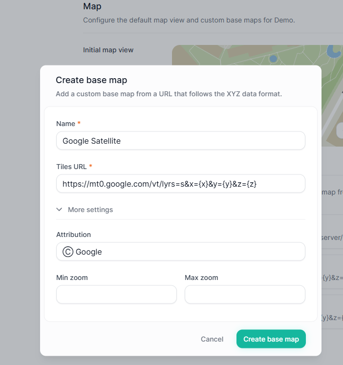
Copy the address exactly as it appears, including the {x}, {y} and {z} parts. These are placeholders that Hortis replaces automatically as you pan and zoom the map. You don't need to change them or work out any numbers yourself.
Ready-to-use map addresses
| Map | Tiles URL | Attribution |
|---|---|---|
| Google Satellite | https://mt0.google.com/vt/lyrs=s&x={x}&y={y}&z={z} | ⓒ Google |
| Google Satellite Hybrid imagery with labels | https://mt0.google.com/vt/lyrs=y&x={x}&y={y}&z={z} | ⓒ Google |
| Google Maps standard street map | https://mt0.google.com/vt/lyrs=m&x={x}&y={y}&z={z} | ⓒ Google |
| Google Terrain Hybrid | https://mt1.google.com/vt/lyrs=p&x={x}&y={y}&z={z} | ⓒ Google |
| Google Roads | https://mt1.google.com/vt/lyrs=h&x={x}&y={y}&z={z} | ⓒ Google |
| Esri World Imagery | https://server.arcgisonline.com/arcgis/rest/services/World_Imagery/MapServer/tile/{z}/{y}/{x} | [confirm Esri attribution wording before publishing] |
| Stadia — Stamen Toner | https://tiles.stadiamaps.com/tiles/stamen_toner/{z}/{x}/{y}.png | © Stamen Design | © Stadia Maps |
Nothing else is needed for these — no account and no API key.
A note on the Google addresses: these are unofficial Google tile endpoints. They work well and are widely used, but please review Google's Terms of Service before relying on them for a public-facing map.
A note on Stadia: the free tier is fine for testing. For a public map you'll need a free Stadia account and an API key added to the end of the address — see Stadia's authentication guide.
Always add the attribution
Map providers require a visible credit. Copy the attribution text from the table into the Attribution field when you create the base map. If you use a service that isn't listed here, check its terms for the wording it expects.
If the map doesn't appear
- Nothing loads, or you see blank tiles. Check the address was pasted in full — it's easy to lose the end of a long address when copying. It should still finish with the
{x},{y}and{z}parts. - The map loads but sits in the wrong place, or looks stretched. The service is probably using a different projection. Hortis needs maps in Web Mercator (EPSG:3857).
- It works for you but not for colleagues. If it's your own map, it may not be shared publicly yet.
Still stuck? Send us a ticket with the address you're trying to use and we'll take a look.
Using your own maps
Have a drone survey, an ArcGIS layer, a WMTS service, or a subscription to Nearmap or Ordnance Survey? See Connect to your own map service.